
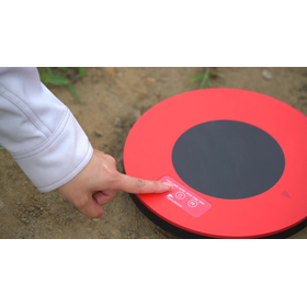
Drone Surveying: GNSS Receiver Built-in Aerial Marker 'AeroBo Marker'
Supports shortened static positioning. Streamlines the process from acquiring coordinates of aerial markers to photo analysis and accuracy management.
The "AeroBo Marker (AS-GM01)" is a drone photogrammetry marker that integrates an aerial marker and a GNSS receiver. By simply turning on the power of the main unit and placing it at the survey site, it can record location information, thereby reducing the process of individually measuring reference points and verification points with a GNSS surveying instrument. By collaborating with the image analysis service "AeroBo Cloud," it streamlines the entire process from marker recognition in photos, matching with the obtained GNSS coordinates, to the creation of orthophotos, 3D point clouds, and accuracy management reports. It can also be utilized for benchmark surveying by attaching it to tripods or leveling bases using a dedicated adapter.
- Company:エアロセンス 本社
- Price:Other
